One of the most significant hurdles for home design professionals in the construction industry is figuring out which software is the right choice for their projects. For compatibility, there are Microsoft and Mac software programs to choose from. These can range from basic, open-source design tools to advanced programs with add-ons and plugins. Some construction software can even be complemented with AI, getting new functionality and allowing for more streamlined processes. Then there is the cost to consider, which can be free to tens of thousands of dollars.
Another issue is that many of these computer-aided design software tools are designed to simulate different things. They work in different phases of the construction process, meaning you need to know how each phase evolves when making the best choice for your workflow. Either way, once you understand the general CAD software principles, it is easier to understand and pick up new CAD software.
There are many different types of construction design software, and they are generally categorized by which profession they are made for.
Top Software
Software for a civil engineer won’t work the same way when the chief architect uses it. You also need to understand building information modeling (BIM), which is the general category that most construction CAD software falls into. However, your choice for architectural design, interior design, and building design software in the industry will always start with your specific situation.
AutoCAD
Software for reliable 2D and 3D drafting
While not specifically built for construction, AutoCAD is the grandfather of professional CAD software. Over the years, it has set the trends in this industry and paved the way for other user-friendly programs such as SketchUp. It has toolkits for many industries, but its architecture toolset is notably quite advanced. With this tool, you can design 2D and 3D models. You can also do things like compare drawings and count objects. AutoCAD also makes it easy to do 2D floor plans, 3D floor plans, elevations, and 3D designs. It gives you all the tools you need to create a useful 3D model that represents what you are trying to create.
Rhino
An affordable entry-level CAD system
Rhino is used by architects and engineers to design, model, present, and analyze various projects. It has multiple editing modes, meaning you can utilize NURBS or traditional geometric tools to create blueprints. It also meshes with a whole host of CAM, engineering, and rendering suites. The best thing about this program is how affordable it is compared to its competition. It even has integration with various digital fabrication tools. For example, it can be utilized with 3D printing equipment.
Autodesk Navisworks Manage
Coordination software that includes clash detection and advanced collaboration
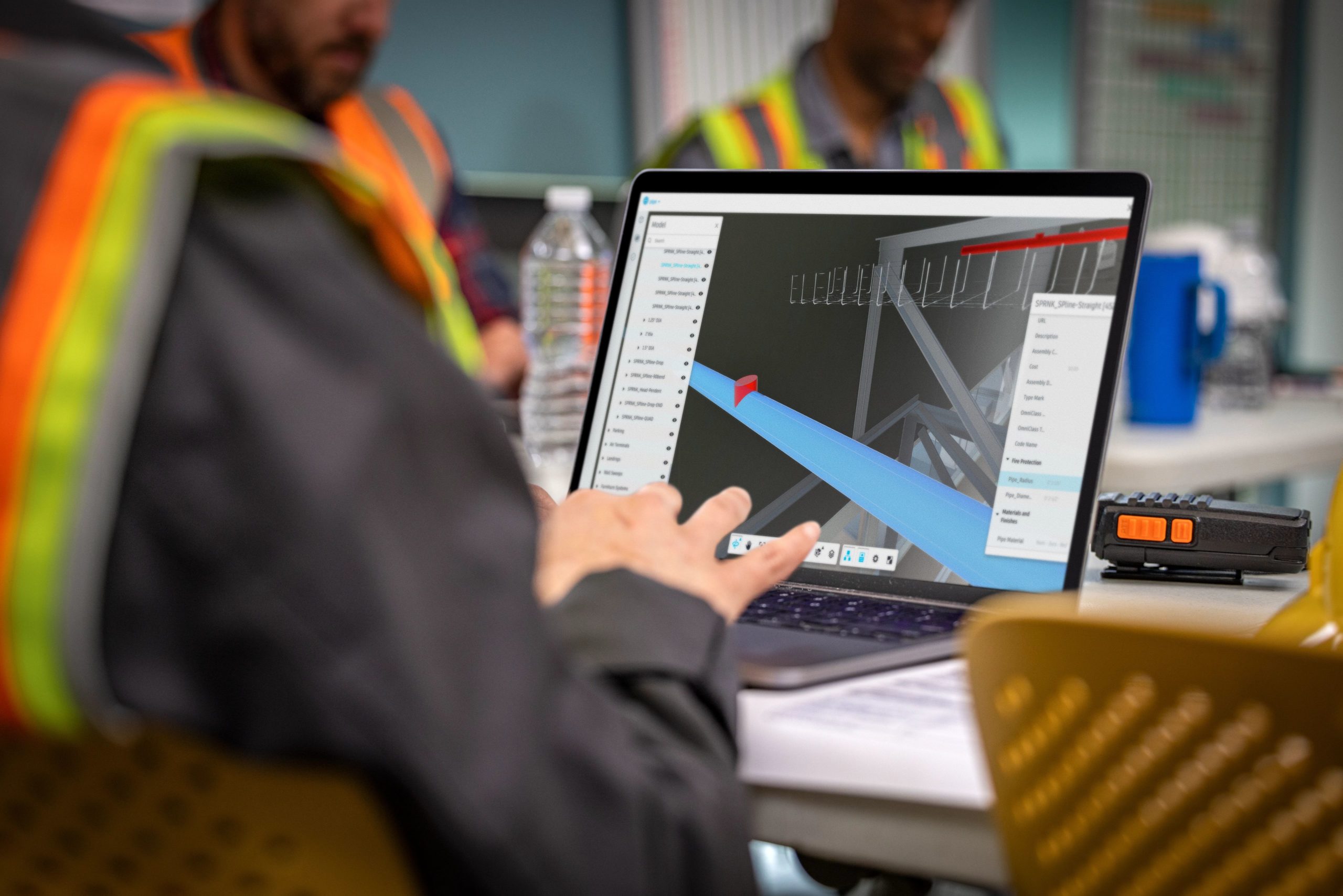
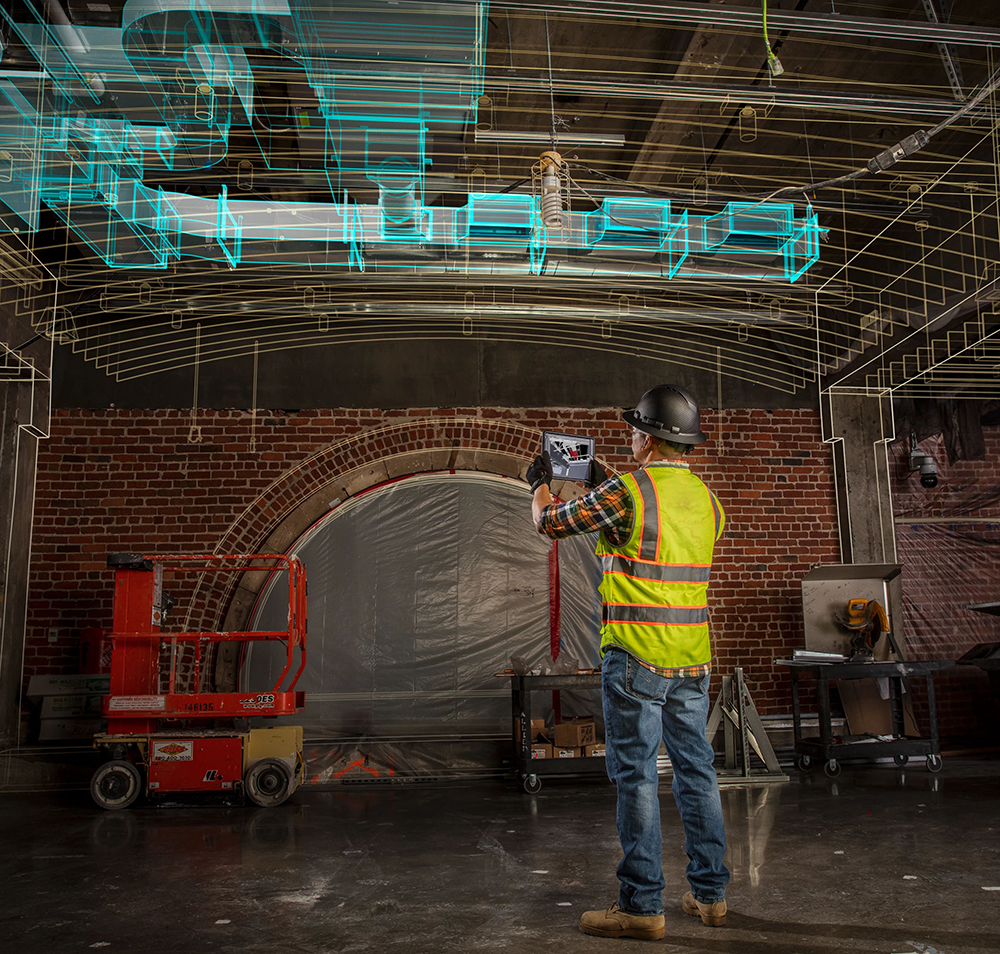
Autodesk Navisworks Manage is an industry leader in advanced collaboration and clash detection. It allows users to combine all design and construction data (architectural, civil, MEP, etc.) into a single model without the dreaded lag common with other programs. This function offers exploration of aggregate models in real-time for advanced visualization and clash detection—a tool that identifies and reports any cross-discipline interferences (clashes). Many users report these features being invaluable both in the early and finishing stages of the design process.
Autodesk Construction Cloud
A construction software bundle for budget-friendly collaboration
Autodesk Construction Cloud is a series of software that supercharges projects with cloud-based collaboration. This different software saves designers time and money by streamlining the entire construction from bid to build—gone are the days of manually tracking changes and managing model updates.
Get your project off to the right start with Autodesk Takeoff to create competitive bids and do in-depth material cost analysis.
Then, once your project is underway, manage construction and field execution with Autodesk Build.
Additionally, the Autodesk Construction Cloud solutions also offer Autodesk Assemble to query and connect BIM data to key workflows. Autodesk Construction Cloud solution is ideal for both large and small businesses—keeping all team members up-to-date throughout the project lifecycle.
Revit
The industry standard for BIM software
Revit is one of the most commonly used tools in the industry. It specifically offers BIM functionality that can be used by construction professionals, civil engineers, and architects. There are many tutorials and walkthroughs available that make it easy to learn, but there is a bit of a learning curve for people just getting started. However, this is mainly because this tool has everything a professional could ever need—meaning it will take many years to master.
There are also plenty of tools for collaboration, meaning you no longer need to be in the same place to work with other engineers and architects on design projects. Additionally, it offers the same simulation and building management functionality you would expect from traditional parametric CAD modelers. If you could only choose one tool to get, this would be the one needed to manage everything in the building lifecycle.
Autodesk BIM Collaborate Pro
Cloud-based collaboration between AEC teams across Autodesk products
Autodesk BIM Collaborate Pro focuses on connecting architectural, engineering, and construction teams. This cloud-based platform makes it easier for AEC teams to connect, collaborate, and create high-quality models in real time on a single platform. The main benefit of this software is that team members can implement changes at any time and from any place in AutoCAD Plant 3D, Civil 3D, Revit, and more.
CAD Pro
2D and 3D home design tools for remodeling and building
Cad Pro provides high-quality drawing tools for remodeling and building. You can even evaluate your designs quickly using built-in tools. This home design software is made for traditional homeowners looking for a powerful CAD solution to help them build or improve their current homes. It offers features that make drawing, visualizing, and collaborating easy. It is the perfect bridge between a powerful professional system and one that doesn’t have the features needed to do anything useful. Finally, it is also an excellent tool for creating landscapes, patios, and other outdoor designs.
Autodesk AEC Collection
A diverse collection of top AEC software
The Autodesk AEC Collection is designed to tackle all design aspects of projects—from design to construction. It bundles the top programs to ensure that designers, engineers, and construction professionals have cloud-based BIM and CAD tools at their fingertips. This collection includes Revit, AutoCAD, Civil 3D, Navisworks Manage, InfraWorks, and more. Beyond the cloud-based capabilities and robust tool set, a considerable benefit of this collection is that it saves you thousands of dollars compared to buying the included programs separately.
Conclusion
There are plenty of CAD modeling tools and software for design and construction. However, note that there is generally no need to have them all—a few should be enough for most projects. The key is to determine your needs as a designer and the needs of your project.
If you are looking for the best of the best, you won’t go wrong with Autodesk Revit. Then there is AutoCAD, which is excellent for working with everything from basic 2D designs to 3D renderings. However, beginners may find more value in the budget-friendly Rhino3D. Need to enhance collaboration ease? The Autodesk AEC Collection or Autodesk BIM Collaborate Pro are good choices.
With the diverse software available, there is truly an option for every design situation. Do you have any questions? Contact us.
Post and beam construction is a building method that utilizes heavy timbers to frame homes. As its name implies, this technique involves creating a system of vertical posts and connecting them with a series of horizontal beams to form the framework of a house. While the origins of post and beam construction date back thousands of years, the construction technique has seen a recent resurgence with the popularity of rustic log homes.
Components of Post and Beam Construction
There are four primary components in post-and-beam construction: posts, beams, trusses, and connectors. The posts, often made from Ceder or Douglas fir, play an essential role in structural integrity as they transfer the weight of a timber frame structure to the foundation. Horizontal beams serve a double purpose. First, they connect the posts together, and second, they provide support for the roof and floors in multi-level homes. Next are the trusses, triangular elements used to evenly distribute loads and give a roof its shape. Lastly, we have the connectors, which have the crucial job of holding everything together.
Types of Post and Beam Construction
Post and beam construction is an ancient form of craftsmanship, and in many ways, the techniques used today remain unchanged. However, over the years, modern fasteners and structural components have expanded the applications for the post and beam technique. Generally, timber construction falls into one of three categories: traditional, modern, or hybrid.
Traditional Timber Frame
Traditional Timber framing takes a historical approach to post and beam construction. This method uses classic joinery techniques like mortise and tenon joints. A technique that involves creating a sort of peg, or “tenon,” on one end of a timber and interesting it into a hole, or “mortise,” of another, which is then secured in place by driving a series of even smaller pegs into the timbers. To many, traditional joinery methods are the most visually appealing. However, they tend to be more expensive than their modern counterparts due to the higher levels of time and craftsmanship needed to complete each joint.
Modern Post & Beam
Modern post-and-beam construction methods combine the aesthetic appeal of traditional timber framing with contemporary structural needs. By incorporating metal fasteners, cables, steel-reinforced lumber, and other modern materials, beams can span larger distances, giving homeowners more flexibility and creativity when creating floorplans for their dream homes.
In addition to increasing structural integrity, securing posts and beams with screws and bolts requires far less time than mortise and tenon joinery, helping to keep costs down while creating an industrial home style that Architectural Digest likens to “the grunge baby between modern and farmhouse aesthetics.”
Hybrid Timber Frame
Hybrid timber framing is a combination of modern construction technology with traditional craftsmanship. A common technique within this style of post and beam construction involves the use of structural insulated panels (SIPs) along with timber framing. SIPs sandwich a rigid core layer between two outer layers of structural board. These high-performance building panels provide superior insulation and energy efficiency, making them ideal for floors, walls, and ceilings.
In terms of aesthetics, hybrid homes often feature exposed beams and trusses combined with conventional wall framing. This method helps maintain a rustic feel while reaping the benefits of an energy-efficient modern home.
Design Considerations for Post and Beam Construction
Post and beam is a specialized building style that requires careful consideration of various architectural, environmental, and structural elements. When designing a timber home, the following factors should be carefully analyzed.
Energy Efficiency
While timber is a strong and beautiful building material, it offers little thermal insulation. To increase a home’s heating and cooling efficiency, high-performance insulation solutions like SIPs should be factored into construction.
Structural Integrity
When designing a timber home, structural engineers need to calculate the load-bearing capabilities of posts, beams, and trusses. Other factors, like wind and snow, will significantly affect the choice of wood species and joint types.
Aesthetic Considerations
Aesthetic feel is often the principal factor for homeowners building this style of home. Some prefer the look of exclusively exposed rafters and beams, while others may opt for an entire log cabin feel.
Wood Species
The appropriate wood species is a critical decision in post and beam construction. Oak is a robust species with a distinctive grain pattern, adding a unique visual aspect to its load-bearing capabilities. Cedar is a common choice for humid climates due to its natural resistance to decay and insects.
Local Building Codes
Building codes vary from region to region. These regulations may dictate the available joinery methods and the number of modern structural components needed for a building.
Applications of Post and Beam Construction
The versatility of post and beam construction makes it common for residential applications. However, this building technique can be used in nearly any scenario that calls for a natural touch and airy feel. Apart from homes, some of the most common types of post and beam structures include:
Commercial buildings: Office lobbies and restaurants often use post and beam building techniques to create open, inviting spaces that feel rustic and modern at the same time.
Agricultural structures: Post and beam construction is a logical choice for agricultural structures since this method allows for large areas free of support columns that could inhibit the movement of equipment and machinery. Additionally, since agricultural buildings are rarely climate-controlled, building with a hardy wood species will allow these structures to endure the elements and stand the test of time.
Recreational facilities: With the rising popularity of events like barn weddings, the demand for rustic event centers has never been higher. When fitted with vintage-style incandescent lighting, exposed posts and beams can create a warm environment for attending guests.
Cost Comparison of Post and Beam Construction with Other Construction Methods
Since the level of craftsmanship of post and beam construction is significantly higher than that of other construction methods, this framing technique tends to be more expensive initially. However, due to the durability and low maintenance costs of post and beam structures, the investment can be more cost-effective in the long run.
Though post and beam construction is an ancient form of craftsmanship, it remains a popular method for homeowners who value durability and aesthetic appeal. When designed with capable BIM software like Revit, post and beam structures can withstand the test of time and display natural beauty for years to come
The construction industry is evolving faster than ever before. As digital technologies further entrench themselves in the field, contractors need to take a progressive approach to all aspects of their business, including their marketing strategies, to stay relevant.
Why Construction Companies Must Embrace Construction Marketing
If you own a well-established construction company, marketing was probably not something that you gave much thought to in the past. However, in recent years, you’ve likely received countless cold calls and emails about website building, SEO services, and Google ad campaigns. These terms may sound like a foreign language to you, but in 2024, they are essential parts of maintaining relevancy in modern construction.
Basically, it boils down to how most homeowners seek information. In the past, they asked their friends and neighbors for recommendations or looked for contractors listed in their local phone book. Nowadays, a quick Google search will provide a homeowner with a list of contractors in their area, and this is where strategic marketing comes into play because the top Google search results are not necessarily the most capable builders but rather the ones with the best construction marketing tactics. There is no ceiling for the time, effort, and money that a company can put into a marketing campaign. Still, there are some essential strategies that make up the backbone of an effective advertising strategy.
8 Construction Marketing Tips and Ideas for Growth in 2024
In 2024, construction firms will be presented with a variety of strategies to enhance their marketing and secure their place in an increasingly competitive construction market. Below is a list of ten tips and ideas you can take to increase your company’s visibility, better engage with your target clientele, and generate a steady flow of new leads. These tips include a modern approach to traditional strategies and digital marketing tactics to ensure a flexible approach that can adapt to a volatile market.
1. Develop a Customer-Centric Website Interface
A well-built website is an important component of an effective marketing strategy, as it is almost always the first point of contact for potential clients. A website is what gives an individual their first impression of a business. So, to ensure that that impression is positive, a company site should be mobile-friendly, easy to navigate, load quickly, and direct visitors to positive client testimonials that highlight customer satisfaction. Additionally, integrating advanced construction management software like Autodesk Takeoff can showcase your firm’s commitment to leveraging cutting-edge technology for efficient project execution and client communication. This can be achieved by integrating the product’s API into a construction materials estimator tool, for example.
2. Google List Your Business
Ensuring your business is listed on Google My Business is another essential step for boosting your online presence. Fortunately, it’s easy to do, and it’s free! All you need to do is create a Google Business profile, add your business through Google Maps, and claim your company under the management section of the site. Once you’ve completed these steps, it will be much easier for people to find your company and contact you. Google listing also provides a platform for your clients to leave reviews about their experiences using your services.
3. Create a Social Media Presence
Forbes Magazine recently stated that 84% of adults use at least one social media site. With so many people on Facebook, Instagram, and LinkedIn today, construction firms are presented with a unique marketing platform to promote their business. High-quality images and videos can be used to post customer testimonials and share project updates. By actively engaging with your followers, you will create a community around your brand, promoting a sense of connection with your audience.
4. Highlight Customer Reviews and Testimonials
Customer reviews and testimonials are invaluable tools for building brand awareness and trust. Client feedback can be posted on your website’s home page and your social media platforms. However, external Google reviews often resonate more with potential clients, so it’s always a good idea to ask your clients to write a Google review if they are satisfied with your firm’s work.
5. Launch Google Local Service Ad Campaigns
Google Local service ads are a powerful marketing tool available to construction companies looking to connect with homeowners in their local areas. When conducting a Google search, these ads appear at the top of the results, providing prime visibility and a direct link to your company’s contact information. Google local service ads are a simple and affordable way to boost your local SEO efforts and attract organic traffic to your website.
6. Create SEO-Centered Content
High-quality SEO (search engine optimization) content like blog posts provides your website visitors with information about your company’s area of expertise while incorporating target keywords and phrases that improve search ranking and drive organic traffic to your website.
7. Build and Maintain an Email List
Email campaigns are one of the oldest forms of digital marketing, but they are still very effective in keeping in touch with past clients and developing new leads. Marketing emails often include updates about new building projects, content blogs, or exclusive offers to keep your business fresh in the minds of both new and past clients.
8. Implement Pay-Per-Click (PPC) Advertising
Pay-per-click advertising (PPC) is an internet marketing model in which businesses pay a fee every time someone clicks on their ads. Basically, it’s a way of buying visits to a website rather than trying to generate them organically through SEO strategies. PPC campaigns can be tailored to target a specific demographic or geographical region, providing control and flexibility over who sees your ads.
Key Takeaways: Elevating Construction Marketing for the Future
Adapting to new digital platforms and innovative forms of advertising is essential for modern construction companies looking to take their marketing strategies to the next level. By focusing on providing your audience with informative and engaging content, you will not only forge a strong customer relationship but also check all the boxes that search engines use to promote your business.
Remember, when creating content, that your goal is not only to attract new clients but also to create a sustainable business model that facilitates long-term growth and client satisfaction in a competitive construction landscape.
Features the latest informative and technical content provided by our industry experts for designers, engineers, and construction firms and facility owners.